Wangaratta Bike Paths |
Wangaratta Bicycle Paths
Tourist Information Centre to Yarrunga |
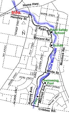
This ride commences at the Tourist Information Centre, southern side of Wangaratta at the large traffic lighted intersection where the old Hume Highway is crossed by Handley and Sisely Streets.
The ride commences at the Tourist Info and virtually follows the One Mile Creek East to Cribbs Road.
 |
Distance: 6.5 km
Road: Mostly bitumen bike path or road
Bike: Any suitable bike for rider
Ride Features: Ride through this area of Wangaratta past a public swimming pool mostly on the safety of bike paths with short connections on quiet streets or street crossings.
0.0 km Wangaratta Tourist Information Centre.
Turn left out of the car park and past the Police Station
0.3 km Left onto bike path at the give way sign then right under the bridge.
1.0 km Playground
1.1 km Road Safety School
1.6 km Yarrunga Scout Hall
3.1 km Cross One Mile Creek then left into Mitchell Ave.
3.5 km Playground
3.8 km Swimming Pool, take unsealed track and cross creek.
Turn right and retrace route to the start.
6.5 km Wangaratta Tourist Information Centre.
 |
 |
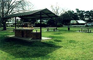
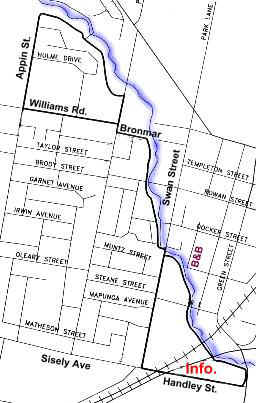
Above is the well planned barbeque and picnic area known as Bachelors Green. This area is parkland behind the Tourist Information Centre and also behind the Police Station. From the BBQ area you commence the ride under a bridge, and out onto the bitumen path.
 |
 |
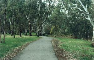
Most of the way is either these lovely bike paths meandering through parklands, and there are some street crossings. Mitchell Avenue is the only street you need ride on if you do the circuit, otherwise you can ride on the paths all the way to Cribbs Road, and then simply turn around and stay on the path all the way to the BBQ location.
Tourist Info. to West End Bike Path |
This ride commences at the Tourist Information Centre, southern side of Wangaratta, at the large traffic lighted intersection where the old Hume Highway is crossed by Handley and Sisely Streets.
The ride commences at the Tourist Info and virtually follows the One Mile Creek West to Appin Street.
 |
Distance: 7.0 km
Road: Bitumen
Bike: Any suitable bike for rider
Ride Features:
Urban bike ride along a pleasant creek on bike paths most of the way. Playgrounds along the way, public swimming pool and water slide towards the end of the ride.
0.0 km Wangaratta Tourist Information Centre. Left out of the car park past the Police Station.
0.3 km Left onto bike path at the give way sign.
0.6 km Batchelor's Green, toilet, playground, barbecue and picnic spot.
1.4 km Take left fork, don't cross the bridge
1.5 km Right into Swan Street, cross the creek, ride on the left shoulder then re enter bike path, cross the creek then turn right.
2.4 km Track enters Bronmar Street
2.6 km Right into Phillipson Street, left onto bike path before the bridge, follow the path along the creek. Don't cross the creek.
3.7 km Enter Appin Street.
4.2 km Left onto bike path in Williams Road.4.8 km Right into Phillipson Street.
4.9 km Left into Bronmar Street, retrace the bike path.
To return, you can either retrace the outward route or take the following option:
6.2 km Continue straight ahead in Swan Street.
6.5 km Swimming Pool, water slide, playground and barbeque.
6.6 km Left into Sisely Ave. Cross Railway line and Old Hume Highway.
7.0 km Wangaratta Tourists Information Centre.
 |
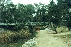 |
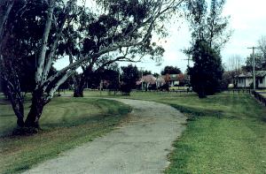
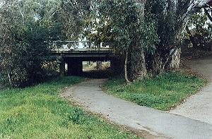
Above is the bridge connecting the bike path to the BBQ area at Bachelors Green on the other side of the Old Hume Highway. Above right shows another of the bridges allowing the bike path to go under another road.
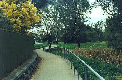 |
The photo above shows the bike path following the One Mile Creek, meandering to the West End.
| Apex Park to Bowser | 5 Km one way |
| Bowser to Tarrawingee Station | 14 Km one way |
| Apex Park to Horseshoe Lagoon | 2 Km one way |
| Apex Park to Northern Beaches | 3 Km one way |
| Tourist Info. Centre to Yarrunga | 3 Km one way |
| Tourist Info. to West End Bike Path | 3.5 Km one way |
Links to the Mountains to the Murray Bicycle Rail Trail |
| Bright to Porepunkah | Porepunkah to Myrtleford | Myrtleford to Everton |
| Everton Stn to Beechworth | Everton to Wangaratta | Wangaratta Bike Paths |
The Up Button will take you to the Home Page