WOOLSHED FALLS HISTORIC WALK |
Page 2
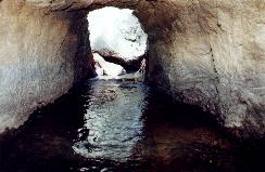
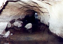
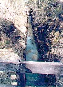
3 DIVERSION TUNNEL
 |
 |
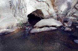 |
Left, Tunnel Entrance, Centre Looking through Tunnel, Right, Tunnel Exit
4 DRY MINING
In this area there is evidence of Dry Mining. The miners scraped out gold bearing soil from between the granite boulders and the panned or sluiced it to extract the gold.
5 REID'S CREEK GOLDFIELD
This area was the scene of much activity during the 1850's. In 1853 there were 8000 miners on the Reid's Creek field and the original settlement was just upstream from here. It had a post office, stores and police camp. Reids Creek was the scene of several riots, when disputes arose over the ownership of claims. At the time there was no proper legislation to ensure fair and orderly granting of claims.William Howitt, an English Author wrote of Reids Creek in 1853:
" for nearly two miles, a wide valley is completely covered by tents and the soil turned upside down by diggers. A more rowdy and uninviting scene I never saw..... all the trees were cut down; the ground where it was not actually dug up was eaten perfectly bare by lean horses... more shabbiness and apparent wretchedness it would be dificult to concieve.
Reids Creek has the character of being a disorderly and dangerous place. There have been no less than fifteen murders committed at it..."
The miners, or diggers as they wore called formed themselves into two groups; the Punchers and the Monkeys. The punchers worked the dry banks and gullies and generally wore moleskins. The monkeys worked the stream and considered themselves superior. Those who had struck it rich wore black woollen trousers and Napoleon boots, and sported silk sashes and gaily coloured kerchiefs.
6 OLD CREEK COURSE
You can see some differences between the original course of Spring Creek seen here, and the new Spring Creek, which you saw at the start of the walk. Here, the creek is much shallower and less eroded. After the creek diversion (Stop 1) was completed, the areas around here was opened up for mining. The alluvial gold was found in three layers of washdirt, 250 to 300 millimetres deep, deposited in three distinct geological periods. Some miners were lucky enough to win as much as 800 ounces from a single claim, originally 8 foot by 8 foot (2.4 metres) square.
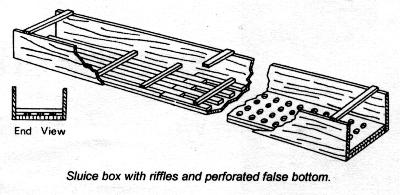
7 WATER RACE
The track here crosses an old water race, one of the many long trenches dug by miners to bring water to their claims. Races were used for sluicing, a method of mining imported from the Californian goldfields, which became more highly developed in the Beechworth district than elsewhere in Victoria.Water was carried to a point where it flowed into sluices, either a series of inclined, interlocking boxes made of sawn board and usually standing on trestles, or channels dug in the ground. Box sluices usually had a series of riffles or narrow slats across the base to catch gold. When the wash dirt was placed in the sluice, the lighter gravels were washed away by the force of the water and the heavier gold particles were left behind.
Nearby are the ruins of a small hut in which Walter Ballart lived in the late 1920's. A recluse, Ballart scraped a meagre living from rabbit trapping and performing odd jobs for local farmers.
8 RAISED WATER RACE
This water race is different from the one at the previous stop. Its wall has been built up and the channel is above ground level, whereas the other race was a channel cut into the ground. To provide this gravity fed water supply the miners had to work very hard with picks and shovels, but usually it was easier to bring water to the claim rather than carry washdirt to water. If you follow this race you will find that it is cut by the creek diversion. Presumably the race was used before the diversion was constructed.
9 GRANITE RACE
This race was cut through solid granite to complete the creek diversion. If you look closely you will see the drill holes in which the explosive charges were placed to remove the rock.The water above the bridge is about one metre deep, and below, up to two metres deep.The new creek was carefully graded to ensure a steady flow of water.
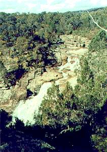
10 WOOLSHED FALLS POOL AND VIEWING PLATFORM
The Woolshed Falls Viewing Platform is above the car park to the north.
Nearly 2000 ounces (57 kilograms) was extracted from the pool below the platform during the years of 1918-1920, much later than other areas around Beechworth.Near the bottom of the falls, on the left hand side, some steel rods can be seen fixed in the rock wall. These rods supported a steel pipe or flume, which extended from the top of the falls to a point downstrearn. Miners diverted water past the pool, which was pumped dry to expose goldbearing material in the sand.
 |
Beechworth Walks |
Woolshed Falls Walk |
Beechworth |
For more Information on Beechworth Tourist Attractions, please call the Information Centre on 0357 283 233 |
The Up Button takes you to the Home Page