CHILTERN HISTORIC FOREST DRIVE |
ITEMS TO SEE BESIDE THE MAGNIFICENT FOREST ARE
as marked on the map above
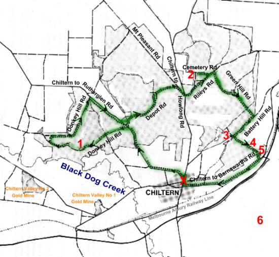
1 Donkey/Donchi Hill Lookout
2 Pioneer Cemetery, 1858
3 Magenta Gold Mine
4 State Battery Site
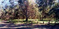
5 Frogs Hollow Picnic Area
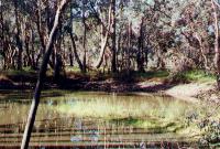
6 Cyanide Dam/ Honeyeater Picnic Area
( across the Hume Highway)
X START / FINISH Tourist Info Centre
This circular drive starts and finishes at the Chiltern Tourist Information Centre, near the corner of Main and Conness Streets, Chiltern. Allow about one and a half hours for the 25 Km trip, as you will be stopping frequently to see the view or the mines. Better still allow more time and pack a picnic lunch.
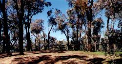
You will see only a part of Chiltern State Park, but these notes, plus your imagination, will give you a good introduction to the mining history of the area. The drive is along all weather gravel roads, suitable for all vehicles. Drive slowly to enjoy the scenery, and watch out for other vehicles along the narrow sections. The route is marked with signs along the way. Start at the Tourist Information Centre and proceed north along Main Street towards Rutherglen. Turn left into the Chiltern Rutherglen Road and proceed about three kilometres to the Donkey Hill Road on your left. There is a signpost on the road. Turn left into Donkey Hill Road, which is a circuit or crescent shaped road, and follow it all the way back to the Chiltern Rutherglen Road. 1 Donkey Hill As you approach this lookout and picnic area, you travel through Box Ironbark Forest. It has changed considerably since gold was discovered in 1858. For 50 years until the early 1900’s the box and ironbark trees were cut to supply timber for the mine and firewood for local people. Since then, timber has been taken for poles and fence posts. Early records show that the original forest consisted of large, well-spaced trees, and a grassy floor. Today the trees are mostly young and straight, and close together. Many of these have developed from coppice growth from the stumps of trees cut down years ago.
The most common trees in the park are Mugga lronbark and Grey Box. Both have timber which is extremely rot resistant and tough and which burns well. Mugga Ironbark has black, hard, deeply furrowed bark up to the small branchlets, whereas Grey Box has grey, fine and flaky bark and small branches.
There are two separate BBQ facilities with picnic tables at Donkey Hill.
 |
|
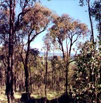
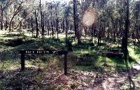
2. Pioneer Cemetery
The cemetery boundary is marked by the white posts. First used in 1858 when thousands of diggers rushed to the Indigo Goldfield. It is thought to be the original cemetery in the area. Joseph Turner was the first person to be buried in the Pioneer Cemetery in 1858. He was 34 years of age.
Very little evidence of the graves remains today although records show that 73 people were buried here. The original grave markers and fences were made of wood but were removed for firewood in 1934 and 1935 during the depression. The cemetery closed in 1859 after only a year of use.
There is some confusion about the location of this goldfield because of the number of places named "Indigo". Barnawartha was called Indigo Settlement, and there was an Upper and Lower Indigo as well. However the goldfield was probably in the area west of the cemetery. It Included a police camp and Court House.
Drive back along Cemetery Road to Riley’s Road, turn left and continue into the forest.
Turn right into Green Hill Road, and then right again at the T intersection into Battery Hill Road. Continue to the Magenta Gold Mine Car Park. This is a turn off to the right whilst you are veering left. Follow the signs.
From the car park you can see the path to the mine, and also the viewing platforms. A complete circuit of the track takes about 15 minutes.
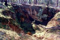
Mining of the Magenta Reef commenced as an open cut operation in 1860. Earth, rock and quartz were excavated and carried out by horse and dray. As the open cut was extended, it was also widened. This brought lower yields, but the increased production kept the mine profitable. The open cut was worked to a depth of 15 metres. (It was later partially filled with mullock).
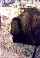
Two shafts were later sunk to win more ore. You can see one of these if you walk up the eastern side of the open cut. This shaft was sunk to a depth of 90 metres, but like hundreds of other shafts in the forest, it has since been filled and sealed for safety reasons.
Follow the gravel track around the northern end of the open cut to the fenced open stope. This enlarged tunnel or drive was worked at a depth of 30 m. The gold bearing ore was removed by excavating the roof of the drive and mining upwards.
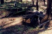
Walk along the track to the site of the mine's quartz crusher or stamping battery. You might see part of the concrete foundations.
About 50 metres further south is the site of Place’s quartz crusher, the timber foundations can still be seen. This crusher operated independently of the Magenta Mine.
The Magenta Mine closed some time after 1910, but there was a minor revival during the Depression years. According to published figures, a total of 2I,665 tons of material was crushed, which yielded 9,900 ounces of gold. However the records are incomplete and it is thought that a yield of 13,000 ounces of gold is more accurate.
In its heyday, Magenta was a significant residential area, and in late1860 people thought it was only a matter of time before trams ran between Magenta and New Ballarat (now Chiltern). The name Magenta may have come from the purplish colour of the rock, or from the Battle of Magenta in Italy in 1859.
|
|
Besides the site you can see a heap of ore which wasn't crushed and just up the hill there are heaps of a sandy material which has been through the crushing and cyanide process.
|
|
|
|
Turning right into the Chiltern Road will take you back to the Tourist Information Centre, just less than 3 kms, where you can obtain brochures or more information on the forest.
| Chiltern Tourist Information Centre | Ph 0357 261 611 |
Chiltern's Parks, Walks and Drives |
| Historic Town Walk | Take A Walk | White Box Walk |
| Aboriginal Walk | Forest Drive | Parks |
The Up Button takes you to the Home Page