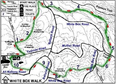
WHITE BOX WALKING TRACK |
The White Box Walking Track will introduce you to some of the natural and historical features of the Chiltern Regional Park. The track is so named because of the tree species which dominates the central section of the walk.This 8.5 kilometre track will take approximately 2 to 3 hours to complete. The numbered posts along the track correspond with points of interest explained here and in the walk brochure.
The Start of the Walk is at the Cyanide Dam, which is about 4Km from Chiltern on the southern or Beechworth side of the Hume Highway.
The White Box Walking Track will introduce you to some of the natural and historical features of the Chiltern Box Ironbark National Park. The 8.5 kilometre track will take about two to three hours to complete. Numbered posts along the track correspond with points of interest explained on this page and in the brochure.
There are many old mine shafts in the area so please remain on the track. All plants and animals are protected and no vehicles including mountain bikes or horses, are permitted on the walking track. (The unsealed roads criss cross the walking track so that you may drive your car to locations nearby and walk a few hundred yards to the points of interest).
As you wander along the track look and listen for the different flora and fauna of the park as well as the occasional mining relic.
Chiltern Box-ironbark National Park is a remnant of a forest type (Box-Ironbark) that was once much more widespread in Victoria. There is less than 15 percent of the original forests left. It is made up largely of Grey Box, White Box, Red Box and Mugga Ironbark. Red Stringybark and Blakely's Redgum are also common.
Originally consisting of large, well-spaced trees and a grassy floor, the Chiltern Box lronbark forest has changed considerably since European settlement. The discovery of gold in I 858 resulted in many of the trees being cut down to supply timber for the mines and firewood for local people. Today the vegetation is mainly regrowth and the trees are mostly young (less than 60 years old) straight and relatively close together.
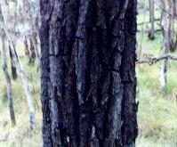 Mugga Ironbark |
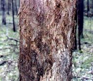 White Box |
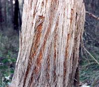 Stringy Bark |
The starting point is at the Cyanide Dam, or Honeyeater Picnic Area.
Walk north-east towards Cyanide Road, turn right (east), and follow the road 300 metres to Bar Trail. Turn left ( north west) onto Bar Trail and proceed uphill.The pile of stones (mullock heaps) you see are the waste material left from mining operations.
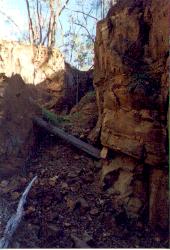
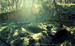
Stop at the entrace to the Wite Box Walking Track. Stand in the Bar Trail Road with your back to the White Box Walking Track. In front of you about 50 metres and slightly to the right is a section of mining from the Golden Bar Mine. ( Photo Below ). Also in front of you but about 100 metres to your left are the remains of the Golden Bar Crusher or Battery. ( Photo Below ). Be careful walking about in these two areas as the ground is quite steep.
The mining to the right of the walk. |
The sun's rays making a mystical light over the battery site for the mine. You can see the concrete foundations and metal posts of the battery which was cut into the side of the hill. Below you can see the mullock heaps of treated soil. |
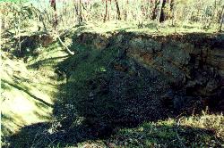
1. Golden Bar Open-Cut Mine
The small open cut you see before you is a reminder of the search for surface gold bearing ore. Most of the gold from this area was extracted from the hundreds of mine shafts sunk throughout the forest. One of the biggest being the nearby Golden Bar Mine.
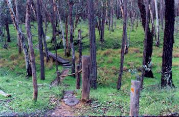
Typical vegetation of the area includes Blakely's Redgum, Mugga Ironbark and Red Stringybark with understorey shrubs such as Daphne Heath, hibbertias and parrot peas. In spring a variety of wildflowers including many native orchids add to the colourful display of the local flora
2. Vegetation of the Ridges. On the ridges the soil is shallower and water run off is higher. Conditions for growth are less favourable resulting in hardier specimens. The smooth barked spindly trees known as Blakely's Redgum or Hill Red Gums dominate the overstorey whiIst Daphne-Heath dominates the understorey.Many understorey shrubs attract small nectar feeding birds such as the Fuscous Honeyeater. The bushy shrub growing either side of the track here is Cat's Claws. Between July and December the orange and red claw shaped flower attracts small necter seeking birds.
The Chiltern Box Ironbark National Park boasts an extraordinary diversity of birds with over 200 species having been recorded within its boundaries.One of the birds in the park that you may be lucky enough to see is the rare Regent Honeyeater. It is a medium sized, mainly black bird with pink wartish skin around its eyes, yellow wing and tail patches. If you do see one, please report your sighting to the ranger.
Notice the vegetation as you descend from the ridge. It consists of Red Stringybark, Mugga Ironbark and a tall understorey of Golden Wattle.
Also look for Cherry Ballart, a small cypress like tree with pine like foliage. Partly parasitic, it takes some of its water and nutrients from other plants. Note the close proximity of a eucalypt host tree. Fruiting from August to September, Cherry Ballarts provide food for native birds in the park. They are also a favourite shady resting site for the Eastern Grey Kangaroos and Black Wallabies. You might be able to see some of their droppings. You can see the occasional termite mounds along the track.
Continuing along the track you will encounter a vehicle barrier. Go around the barrier and cross over Ballarat Road and re enter the walking track on the other side. 3. Vegetation Change Examine the vegetation changes in this area. The Ironbarks and Stringybarks have given way to a mixture of Apple Box, White Box, Red Box and large Blakely's Redgums.The vegetation change is mainly due to the increase in the amount of soil and water. The damp moist gully is also favoured by Tall Sedge and rushes. Reptiles, including skinks, may also be seen.
4. Fuel Reduction Burns Fuel reduction burns are carried out to decrease leaf litter and bark on the ground which assists in the control of wildfire. Compare the vegetation on either side of the walking track. The area on your left has had a 'fuel reduction burn' (note the charring on the stringybark trees). The understorey is denser due to the regeneration resulting from the burn.Many plants such as wattle and pea-flowers require fire for germination. Their seeds may lay dormant in the ground for years then suddenly germinate when fire cracks the hard seed coat.
Further along this section of the walking track look out for some of the few remaining large remnant box or ironbark trees. Nearly all of the large diameter trees were removed during the early gold mining days or from subsequent forestry operations.
These old remaining trees have large hollows which provide habitat for larger tree dwelling mammals such as Brushtail or Ringtail Possums as well as Barking and Powerful Owls.
5. Quiet Area Take a seat on the sawn off stumps and relax for a moment.
| Chiltern Tourist Information Centre | Ph 0357 261 611 |
Chiltern's Parks, Walks and Drives |
| Historic Town Walk | Take A Walk | White Box Walk |
| Aboriginal Walk | Forest Drive | Parks |
The Up Button takes you to the Home Page