|
Bicycle & Walking Tracks |
Lavington to Albury Path |
Lavington to Albury Bicycle / Walking Path
The Lavington to Albury Bicycle and Walking Path follows the Bungambrawatha Creek from the Lavington Primary School in Urana Road to the Botanical Gardens at the west end of Dean Street.
From Dean Street the path as such stops, but recommences about 600 metres away on the other side of the Albury Football Ground in Hovell Tree Park. This path connects to the Wodonga Bike Paths. See Below.
Lavington Primary School, Urana Road, to Botanical Gardens, Dean Street 5.3 Km
Urana Road to Union Road 1.5 Km
Union Road to North Street 2.0 Km
North Street to Dean Street 1.8 Km
Connection to Hovell Path 0.6 Km
Urana Road to Union Road 1.5 Km
|
|
The Lavington to Albury Bike Path commences at Urana Road near the Pearsall Street intersection. This is opposite the Lavington Public School. The Bungambrawatha Creek crosses under Urana Road here, and the Bike Path follows the creek all the way to Dean Street at the Botanical Gardens.
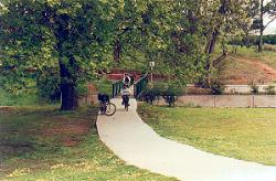
The photo above left shows the path commencing at the school crossing in Urana Road and crossing the creek over a small green bridge. To the right of this bridge is a car park where you may leave your car until you return.
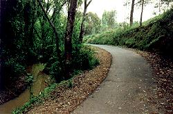
Heading left, you will pass through a small valley, photo above right, with the creek on your left.
 |
 |
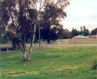 |
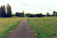
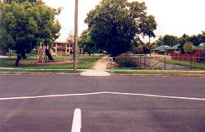
Emerging from the little valley you will come out on Heathwood Park, photo above left, and you peddle through the park until you come to Oliver Street. You must cross Oliver Street, and turning left over the creek, the bike path is on your right. Proceed down the bike path.
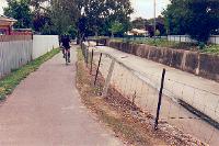
The Creek is now on your righthand side, and it has changed from a pretty country creek to a huge concrete drain. This is part of the flood prevention policy of the council. As you ride on a further few hundred metres, and the creek veers to your right, if you look closely at the "paddock" you are in, you will notice that there is a grassy levee bank all around you.
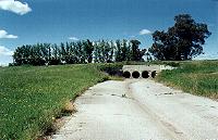
You are now actually in a water reservoir, or a water holding area, as when there is a huge downpour, the only way for the water to get out is through the four pipes which block the drain or creek at the southern end of this park, photo above centre. If there is more water coming down the creek than can get through the four pipes, the water will backfill this whole park from Union Road to Oliver Street. This is known as the Lavington Storm Water Retarding Basin.
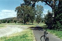
Near Union Road you must pedal faster to ride up the Dam Wall, or Retarding Basin Wall, where you ride over the creek again above the retarding pipes, and then down the wall to cross over Union Road. The photo above right shows the Union Road crossing with the creek now on your left.
Union Road to North Street 2.0 Km
 |
 |
 |
Crossing Union Road you peddle towards the North Albury Bowling Club, and then veer right into Frederick Park, photo above left, and head towards Logan Road. Above centre is a photo looking back into Frederick Park, looking towards the North Albury Football Ground.
Unfortunately at Logan Road there are no signs to tell you where to go, but cross Logan Road and continue south down Fairview Drive. Right at the end of the street you will pick up the bike path again, but only for a few hundred mertres. The path stops at Ryan Road. Ahead of you you can see the Golf Course, and the creek is to your left.
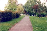
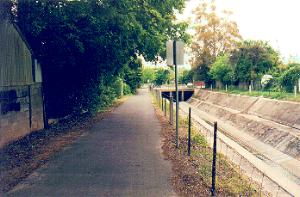
Turn left and proceed down Ryan Road, veering right at the Cemetery, into St James Cresent, and keep going straight. At the end of St James Cresent you again pick up the bike path as it heads towards the Netball Courts at North St. Above right is a photo of the path at the end of St James Cresent.
North Street to Dean Street 1.8 Km
 |
 |
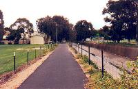 |
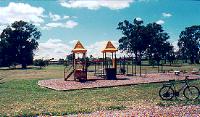
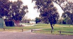
Crossing North Street enter the car park of the Netball grounds, with the creek on your right, and pedal past the rollerblading dish and rollerblading barrel jumps, photo above left. The path now is right next to the creek, photo above centre. You cross over a few streets, the major one being Kiewa Street, and then pass the Albury High School, photo above right.
 |
 |
Crossing over Jones Street the path narrows a bit, and then heads towards Wyse Street, photo above left, and crossing Wyse Street the Bike Path ends at Stanley Street, photo above right. You can see a small park with a dirt path leading to Creek Street. Pedal down the dirt path and down Creek Street to the Traffic Lights at Dean Street.
The Botanical Gardens are opposite Creek Street, and the Main Shopping Street of Albury is to your left, and Monument Hill Lookout is to your right.
Connection to Hovell Path 0.6 Km
By continuing south down Wodonga Place, you will pass the Botanical Gardens, cross over Smollet Street, and pass the Albury Football Ground, you will come to three large parks, Hovell Tree Park, Australia Park and Norieul Park. The Explorers Trail commences at the Famous Hovell Tree. Click on the link below to see the Hovell Tree Path.
Links to Other Bicycle Paths |
| Murray River Bike Path | Border to Wodonga Stn | Border to Willow Park |
| Lavington to Albury | Albury Hovell Tree Path | Bright Rail Trail |
The Up Button will take you to the Home Page